Shira Route
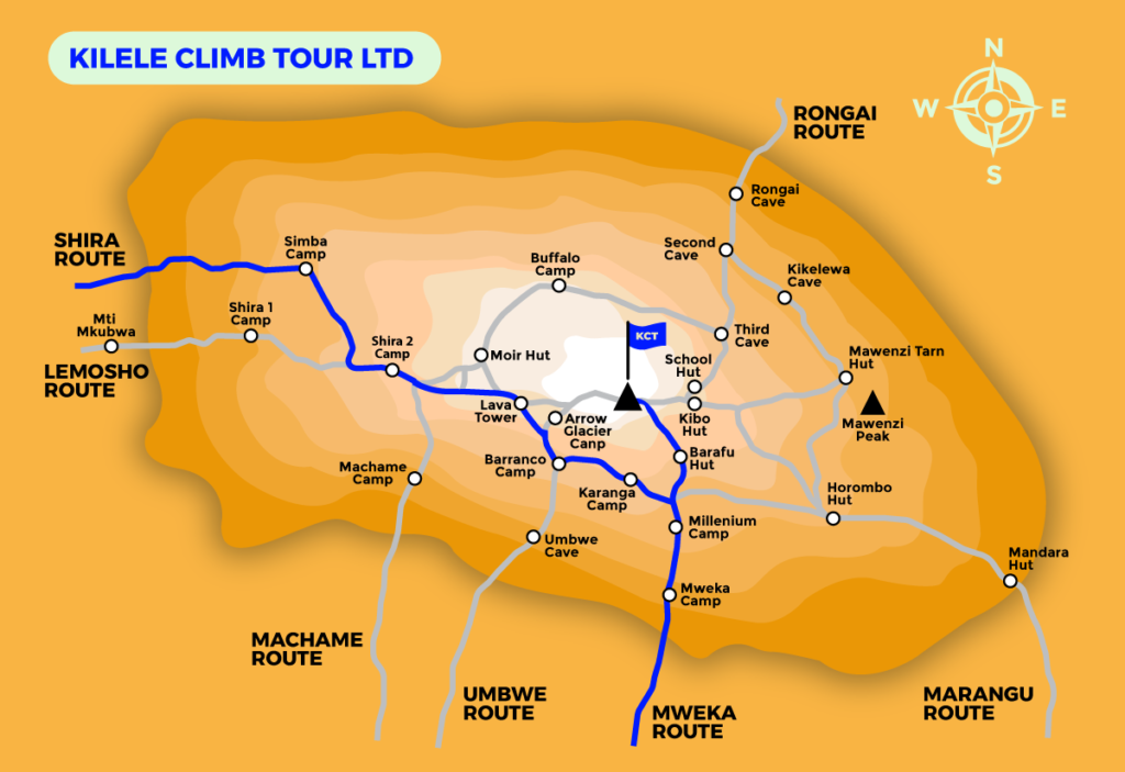
The Shira Route is a less commonly used trail that commences near Shira Ridge. It is almost identical to the Lemosho route, with the exception that Shira was the original trail and Lemosho is the upgraded version.
While Shira is an attractive and diverse route, it is not as favorable as its successor because it has a relatively high-altitude starting point which is quickly accessed by vehicle.
Climbers may experience altitude-related symptoms on the first day while camping at 3,505m/11,500 feet. The Shira route has several variations and can be done in 6, 7, or 8 days.
Facts:
- Choose longer days of the trek as your body needs time to adjust with the high-altitude acclimatization.
- Trekking poles will become your best friend on the harsh trails.
- Take it easy and don’t try to rush to the top and always listen to your guide.
- Drink lots of water and stay hydrated.
- The amount of Oxygen on the top is only 50% as compared to the amount of Oxygen you are used to have. So, pay attention to your body signals and inform your guide as soon as possible.
- Choose the dry season to experience your trek the most.
- If possible, avoid taking pills like Diamox. It may show harmful side effects.
- Pack the necessary gears and double-check the complete list.
- Prepare a ‘Kilimanjaro playlist’ to listen to during your hike which helps to break your mental stress and physical exhaustion.
- The starting point of the route is the Shira Ridge.
- The route approaches Mount Kilimanjaro from the west
- The route is quite similar to the Lemosho route
- The Shira route is considered moderate but starts at a high altitude of 11,500 feet, posing immediate challenges for climbers who can't acclimate quickly.
The route approaches Mount Kilimanjaro from the west, starting with a long drive from Moshi to Shira Ridge. The vehicle bypasses the rainforest zone, and the hiking trail begins on Shira Ridge. The Shira route crosses the entire Shira Plateau from west to east in a pleasant, relatively flat hike, before traversing beneath Kilimanjaro’s Southern Ice Field on a path known as the Southern Circuit. The summit is reached from Barafu. The descent is made via the Mweka route.
The weather of Kilimanjaro is unpredictable throughout the year. The temperature on the mountain varies widely depending upon the altitude.
June to October to the beginning of March offers the best time to climb the mountain.
Different climatic zones offer different atmospheres. The temperatures and precipitation levels and vegetation drops as hikers move to a high altitude.
As the weather varies, so the hikers should be ready to experience the hot, wet or cold conditions at any time while on the mountain.
The Limited availability of data makes it difficult to establish the success rates for the Shira route. However, based on the information at our disposal, a success rate of 65% is estimated for the 6-day Shira route, 75% for the 7-day Shira route, and 90% for the 8-day Shira route.
- Stunning views
- Varying landscapes and hiking terrain
- Quieter than other routes near the start
- Poor acclimatization at the start due to the high starting point.
- Skips the beautiful forest section that Lemosho has.


